Clouds, Computers, and the Coming Storms

Photo courtesy of NASA's Earth Observatory
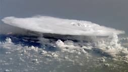
Herds of anvil-shaped clouds form in the tropics as part of the Madden-Julian Oscillation, a pattern of shifting winds and rain that starts over the Indian Ocean and travels eastward every 30 to 90 days. This image, taken from the International Space Station over western Africa, shows the complex nature of these systems.
A herd of thunderstorms roughly the size of Alaska gathers over the Indian Ocean and creeps eastward in pulses: strong winds and torrential downpours peter out, giving way to softer winds and sunny days. The storms rain out, reform, fade, and stir up trouble on and on around the planet's equator. The sheer size and magnitude of these pulses can set off hurricanes, monsoons, and polar vortexes. The pulses also may trigger the El Nino system. While the individual storms are often given clever names and maps of their progress fill our screens, they are part of something much bigger. They are actually beats in the MJO symphony, which circumnavigates the globe every 30 to 90 days.
The MJO, or the Madden-Julian Oscillation, is named for Roland Madden and Paul Julian, who first saw the pattern in the early 1970s. Writ large, the MJO works by pulling in moist air from Earth's surface and causing it to rise and heat the upper atmosphere. Visualize a stock pot full of water centered on a small burner. Crank up the heat on the burner and the water in the middle warms up. The warm water moves up. In doing so, colder water from the edges is pulled in – causing the temperatures to circulate.
The burner is the warm tropical Indian Ocean and the resulting circulation pattern is the MJO, and the large pot represents the global atmosphere. That circulation in the atmosphere affects the weather near and far. For example, a particularly strong pulse of the MJO during the colder months in North America can pull a massive amount of cold air in from Canada toward the equator creating a polar vortex over the nation's capital.
The MJO's complexity, in part, limits weather forecasts and makes it harder to protect people and property from floods, cyclones, snowstorms, or other events. Longer range forecasts could help power companies anticipate energy demands, hospitals prepare for winter-related illnesses and injuries, and shipping and travel industries create safer, more efficient schedules. For scientists, understanding the physics of the MJO would also lead to more detailed simulations of climate variations that can inform critical decisions across the nation.
But how do you study a phenomenon that spans the globe and has more moving parts than a dozen Thanksgiving Day parades in New York City?
ARMing climate models. The answer involves detailed data and supercomputers. The data challenge is partially answered by the Atmospheric Radiation Measurement (ARM) Climate Research Facility. Run by the Department of Energy's Office of Science, the facility's mission is to collect and provide hundreds of terabytes of free data, from land, sea, and air measurement stations, to the scientific community. The ARM team also leads international campaigns, such as the ARM MJO Investigation Experiment, nicknamed AMIE (pronounced like the woman's name).
The second half of the challenge comes in analyzing the data and developing and evaluating simulations to represent it. Run on supercomputers, the models let scientists visualize the data and study the roles of various processes. However, accurately modeling the MJO, which acts on a large scale but involves small events, is difficult. In fact, 80 percent of the major climate models cannot faithfully reproduce the MJO's start and progression.

Photo courtesy of ARM Climate Research Facility
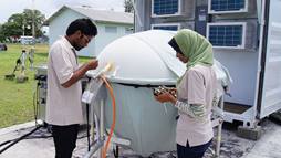
Local observers on Gan Island prepare an instrument for launch as part of the AIME campaign in the winter of 2011.
Building blocks or instigators? What causes the MJO to start up? There are many theories since there are so many factors, and researchers are still searching for clues in the storms. Scientists looked at the small, puffy clouds that decorate miles of the sky over the Indian Ocean as the culprits, thinking that they draw in moisture and serve as the building blocks for the anvil-shaped storm kings. However, Chidong Zhang and his colleagues at the University of Miami pored over the AMIE data and other ARM data sources, and found that the shallow clouds only provide a foundation to build the first pulse on. The clouds aren't the instigators, but they aren't innocent bystanders either.
Courtney Schumacher and Cara-Lyn Lappen at Texas A&M University delved further into the role of these clouds. These clouds, and in fact, all clouds produce heat when their moisture condenses to form rain. This heat, researchers determined, is more important to the models than previously thought. However, the math involved in representing the cloud heat in the climate modeling grids is not a simple addition. It must be carefully fit in or it can cause problems elsewhere in the simulation. Lappen and other modelers work very hard to keep the various threads of the model untangled.
"The MJO is complicated to measure and observe," said Lappen. "We're trying to get as close to reality as we can."
An invisible culprit. So, what sets off the first wave of the MJO? Samson Hagos at Pacific Northwest National Laboratory and his colleagues counted, categorized, and analyzed thousands of clouds near the MJO's starting point, and found the culprit is invisible. A simultaneous buildup of moisture a few miles above the Earth's surface and strong upward motion that lifts up moist air from the ocean's surface is what creates the anvil-shaped storm kings that slowly move eastward.
Then what? The answer lies in something as small as the size of the raindrops in the first storm. Just as evaporating sweat cools the skin, so evaporating raindrops cool the air. Large drops evaporate slowly and provide less cooling. Small drops evaporate quickly. When the first storm has small raindrops, it creates large pools of cold air that sink to the surface and push warm, moist ocean air upward, creating the next set of clouds and so on.
While it is surprising that something as massive as the MJO has its roots in the size of raindrops, it is far from the last secret the MJO holds.
As new storm clouds gather over the Indian Ocean, the MJO starts its next journey. As it travels on, scientists continue delving into the data and refining models to better predict how this agent provocateur of storms will change -- and be changed by -- our climate. The stakes are high as the safety of lives and properties will benefit from understanding this sweeping system.
The Office of Science is the single largest supporter of basic energy research in the physical sciences in the United States and is working to address some of the most pressing challenges of our time. For more information please visit http://science.energy.gov.
Kristin Manke is a Communications Specialist at Pacific Northwest National Laboratory on detail to the U.S. Department of Energy's Office of Science, [email protected].


